


Page 320 - New Medley 5 Semester 1
P. 320
The ratio between the map distance and the ground distance is called the

                      scale of the map. Suppose the map distance between Delhi and Jhansi is
                      4 cm and the ground distance between them is 400 km, then the scale is

                      4 cm : 400 km or 1 cm : 100 km.

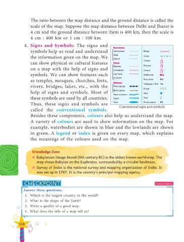
                 4.  Signs and Symbols: The signs and

                      symbols help us read and understand
                      the information given on the map. We

                      can show physical or cultural features
                      on a map with the help of signs and

                      symbols. We can show features such
                      as temples, mosques, churches, forts,

                      rivers, bridges, lakes, etc., with the
                      help of signs and symbols. Most of

                      these symbols are used by all countries.
                      Thus, these signs and symbols are

                      called the  conventional symbols.                            Conventional signs and symbols
                      Besides these components, colours also help us understand the map.

                      A variety of colours are used to show information on the map. For
                      example, waterbodies are shown in blue and the lowlands are shown

                      in green. A  legend or  index is given on every map, which explains
                      the meanings of the colours used on the map.


                       Knowledge Zone

                         ? ? Babylonian Imago Mundi (6th century BC) is the oldest known world map. The
                          map shows Babylon on the Euphrates, surrounded by a circular landmass.
                         ? ? Survey of India is the national survey and mapping organization of India. It
                          was set up in 1767. It is the country’s principal mapping agency.


                                                                                                           • Critical thinking
                 Answer these questions.
                   1.  Which is the largest country in the world?

                   2.  What is the shape of the Earth?
                   3.  Write a quality of a good map.
                   4.  What does the title of a map tell us?


              318

