


Page 316 - New Medley 5 Semester 1
P. 316
Competencies
                                                                                                           C-5.2, C-5.3


                                                                                                     •  Critical  thinking
                                                                                                     •  Information  literacy
                                                                                          21st CENTURY SKILLS
                    1          Globe and Maps


                     Warm Up


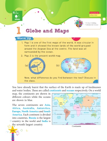
                           1.  Map 1 is one of the first maps of the world. It was circular in
                              form and it showed the known lands of the world grouped

                              around the Aegean Sea at the centre. The land was all
                              surrounded by the ocean.

                          2.  Map 2 is the present world map.


                               (a)                                 (b)


                               Now, what difference do you find between the two? Discuss in
                              the class.


               You have already learnt that the surface of the Earth is made up of landmasses
               and water bodies. These are called continents and oceans respectively. On a world
               map,  the  continents  are  shown  in

               different colours while the oceans
               are shown in blue.


               The seven continents are  Asia,
               Africa, Australia, Antarctica,
               Europe, North America and South

               America. Each continent is divided
               into countries. Russia is the largest

               country in the world and India is
               the seventh largest country.
                                                                                      Continents

              314

