


Page 240 - New Medley 3 Semester 1
P. 240
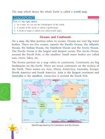
The map which shows the whole Earth is called a world map.
• Critical thinking
Tick () the right option.
1. At a time, we can see the (whole/part) of the Earth.
2. A model of the Earth is called a (globe/map).
3. A book of maps is called a/an (atlas/world map).
Oceans and Continents
On a map, the blue portion refers to oceans. Oceans are very big water
bodies. There are five oceans, namely the Pacific Ocean, the Atlantic
Ocean, the Indian Ocean, the Southern Ocean and the Arctic Ocean.
The Pacific Ocean is the largest and deepest ocean. The Arctic Ocean,
around the North Pole, is the smallest. Small water bodies are called
seas, rivers, lakes, etc.
The brown portion on a map refers to continents. Continents are big
landmasses on the Earth. There are seven continents on the surface of
the Earth. Their names are Asia, Africa, Antarctica, Australia, Europe,
North America and South America. Asia is the largest continent and
Australia is the smallest. Antarctica is around the South Pole.
World map showing the Continents and the Oceans
238

